The origin of Jambudweepa and
Bhartavarsha as per vedic cosmology
Geography of the World in the
Ancient times
According to our Indian geography in the ancient times,
the entire landmass in the northern hemisphere was encircled by ocean in all
the directions. This giant land mass on earth was called Jambudvipa. In
Sanskrit language dwipa means an Island. Jambudveepa consisted of modern Asia,
Europe, Africa and North America.
This Jambudvipa was divided into nine varshas
(geographical regions) of which one was Bharatha Varsha. The other eight
varshas were Ketumula Varsha, Hari Varsha, Ilavrita Varsha, Kuru Varsha,
Hiranyaka Varsha, Ramyaka Varsha, Kimpurusha Varsha, Bhadrasva Varsha.
Of these, Ilavrita Varsha was at the present North Pole
(the Arctic Region)!
 Approximate
Geography of the Ancient World
Approximate
Geography of the Ancient World

The above picture depicts the Geographical
Map of the very ancient times mentioned in the Vedas/Scriptures. The Map elucidates
in detail the image of Jambudvipa and the nava varshas here. In the exact
centre of Ilavrita Varsha, the North Pole was located. To the west of Ilavrita
varsha was said to be Ketumula Varsha which is under under Atlantic Ocean
today, was situated to the west of Ilavrita varsha. Bhadrasva Varsha which is
today under Pacific Ocean, was supposed to be on the east of Ilavrita varsha.
On one side of the Ilavrita Varsha were Hari Varsha, Kimpurusha Varsha and
Bharatha Varsha. On the other side of the Ilavrita Varsha were Ramyaka,
Hiranyaka and Kuru Varsha. Kuru Varsha was hence on the opposite side of
Bharatha Varsha on the globe.
It can be observed that in those times, most
of South American continent, southern half of African Continent and entire Australia
were submerged under water. On the other hand most of modern day Atlantic Ocean
and Pacific Ocean, and the entire Arctic Ocean were above sea level.
Bharathavarsha- the name
and glory of ancient India
In the Ancient Times India was called
Bharathavarsha and it extended in the west including modern Egypt, Afghanistan,
Baluchistan, Iran, Sumeria upto Caspian Sea (which was called Kashyapa Samudra
in those days). Bhratahvarsha was the Greater India while Bharatha Khanda
referred to the Indian Subcontinent which lies at the heart of the Vedic
Civilization and extended from Himalayas in the north to KanyaKumari in the
South. Hence the aryan invasion theory of a migration of Aryans from Central
Asia to modern northern India is a wrong theory,for the entire ancient aryan
civilizational geography spanned across the above mentioned regions. The very
term “arya” in Sanskrit refers not to any race, but actually means a “noble
person”.
According to our Puranas and Ithihasas, Bharatha
Varsha are full of historical developments. During the vedic period, the vedic
civilization spread across the Bharata varsha. Saraswati River mentioned numerous times in
the vedas is the cradle and heart of this vedic civilization, has dried up soon
after the end of the Mahabharatha war, owing to geological events in that
region. As a consequence of this, earlier lush green area of the present
Rajasthan had got converted into a desert as we see it today.
The Arabian Sea did not exist during the
ancient times and the land mass stretched continuously from modern India to
Africa. The mighty Saraswati River born in the Himalayas flowed for over 4500
miles into Africa before entering the Oceans. This was the largest and longest
river in those days. This is the most mentioned and praised river in the Veda.
Of the three Ganga Yamuna and Saraswati – the existence of the first two rivers
flow even today, but Saraswati till recent times was thought to be a mythical
river. On the contrary, a recent satellite photographs and geological data revealed
the existence of an ancient mighty Saraswati river and its geographical span.
The name bharathavarsha
The Sanskrit word bhārata is a derivation of bharata. The root of the term is bhr-, “to bear
to carry”, with a literal meaning of “to be maintained”. The root bhr is
cognate with the English verb to bear and Latin ferō.
Interestingly, the term
Dharma, which is the core concept of Indian values, is derived from the root
dhr, meaning – to uphold or to nourish. Both the terms Bharatha and Dharma,
eventually signify that which supports universal order or the orderly existence
of the individual in life.
The first Article of the
Constitution of the Republic of India states, “India, that is Bharat, shall be
a union of states.” Thus, India and Bharat are equally official short names for
the Republic of India. The name Hindustan was used in historical contexts,
especially in British times.
Bharatha Varsha was not
always called by that name. Its earlier name was Aja_nabha_Varsha. Before that,
it was Himavath Pradesha. In order to know the reason behind this country’s name
as Bharathvavarsha, we have to go back to Swayambhu Manu, the progenitor. His
son was Priyavarta, a great monarch. His son was Agni_dhara. His son was
Ajanabha also called Nabhi. Ajanabha was a very virtuous and a noble king.
During his reign, the land came to be known as Ajanabha_Varsha. Ajanabha’s son
was the great Rsabhadeva. . He was a saintly king. Rsabha renounced the kingdom
in favor of his son Bharata and became an ascetic. Bharatha was one of the most
pious and noblest of Monarchs of his line. He nourished and nurtured his
subjects righteously. During his time, the land that was until then called
Aja_nabha_Varsha came to be known, as Bharatha Varsha. It has been so since
then. Ajanabha (Nabhi), Rsabha and Bharatha figure prominently in the Jain
tradition.
What we call Bhatatha
Varsha or Bharatha is named after a very virtuous and noble king Bharatha. The
best we (who are born and who reside in his land) can do is to be worthy of his
name.
Obviously, in the olden
days being born in Bharath was a matter of pride. In the Gita, Krishna often
refers to Arjuna as Bharatha, the noble one.
Over
the centuries the name of Bharatha Varsha, its shape and its extent have
changed many times. Whatever is its present name, either borrowed or assigned;
whatever the extent of its boundaries is; the concept of India that is Bharath has survived as a many
dimensional splendor; even amidst the encircling chaos? It has always been a
nation. India has held on to its pluralism, its democratic way of life and its
basic values; despite strife, contradictions and endless diversities. This is
no mean achievement. It is for these reasons we call it, the Miracle that is
India.
Rig Veda mentions the
tribe of Bharathas several times.
The Rig Veda has a
certain geographical horizon. It projects a land of seven great rivers bounded
by several oceans and many mountains. It mainly shows the geographical sphere
of the Bharatas and their neighbors. Accordingly, Rig Veda mentions that Bharathas
ruled the land that spread over the banks of the rivers Parushni (Ravi) and
Vipasa ( Beas ).
1. The Purus and in particular the Bharatas among them, are the main Vedic Aryans of the Rig Veda.
2. Bharatha son of
Dushyanta
Bharathas were a clan
among the Purus. The Purus prospered in the North and strengthened the Chandra
vamsha (Moon Dynasty). Many generations later into this, clan was born Bharatha
son of Dushyanta. The great poet Kalidasa in his epic Abhignana Shakuntalam
immortalized the love of Dushyanta and Shakuntala.
As per the chronology
listed in Vishnu Purana,,Bharatha son of Dushyanta appears thousands of years
after Emperor Bharatha son of Rshabha. Deva. Pandavas and Kauravas are
decedents of Dushyanta/Bharatha but are several generations far away from them.

Map of Jambudwipa as per vedic
cosmology
According to Vedic cosmography, the entire Cosmos is
divided into seven concentric island continents (sapta-dvipa vasumati)
separated by the seven encircling oceans, each double the size of the preceding
one (going out from within). The seven continents of the Scriptures are stated
as Jambudvipa, Plaksadvipa, Salmalidvipa, Kusadvipa,
Krouncadvipa, Sakadvipa, and Pushkaradvipa. Seven
intermediate oceans consist of salt-water, sugarcane juice, wine, ghee, curd,
milk and water respectively. Continent Jambudvipa (Indian Blackberry
Island), also known as Sudarshanadvipa, forms the innermost
concentric island in the above scheme. Its name is said to derive from a Jambu
tree (another name for the Indian Blackberry). The fruits of the Jambu
tree are said, in the Viṣṇupurāṇa to be as large as
elephants and when they become rotten and fall upon the crest of the mountains,
a river of juice is formed from their expressed juice. The river so formed is
called Jambunadi (Jambu River) and flows through Jambudvipa, whose inhabitants
drink its waters. Insular continent Jambudvipa is said to comprise nine varshas
(zones) and eight significant parvatas (mountains). "According to some
erudite scholars, Jambudvipa is surrounded by eight islands that are smaller in
size ... called Svarnaprastha, Chandrashukla, Avartana, Ramanaka,
Mandaraharina, Panchadzhanya, and Simhala Lanka.
The seven oceans respectively contain salt
water, sugarcane juice, liquor, clarified butter, milk, emulsified yogurt, and
sweet drinking water. All the islands are completely surrounded by these
oceans, and each ocean is equal in breadth to the island it surrounds. Mahārāja
Priyavrata, the husband of Queen Barhiṣmatī, gave sovereignty over these islands to his
respective sons, namely Āgnīdhra, Idhmajihva, Yajñabāhu, Hiraṇyaretā, Ghṛtapṛṣṭha, Medhātithi and Vītihotra. Thus they all became kings by the order of their father.
It is to be understood that all the dvīpas, or
islands, are surrounded by different types of oceans, and it is said herein
that the breadth of each ocean is the same as that of the island it surrounds.
The length of the oceans, however, cannot equal the length of the islands.
According to Vīrarāghava Ācārya, the breadth of the first island is
100,000 yojanas. One yojana equals eight miles, and therefore the breadth of
the first island is calculated to be 800,000 miles. The water surrounding
it must have the same breadth, but its length must be different.
Detailed explanation of
Jambudweep
According to Puranic cosmography, the entire
Cosmos is divided into 7 continents (sapta-dvipa vasumati) separated by the
seven encircling oceans, each double the size of the preceding one (going out
from within). The seven continents of the Puranas are stated as:
Jambudvipa, Plaksadvipa, Salmalidvipa, Kushadvipa, Krounchadvipa, Shakdvipa,
and Pushkaradvipa.
1.
Right
in the centre of everything – Is the Sumeru Mountain – Surrounded by the 1st
continent – Jambudvipa, which then, like a moat is surrounded by Salt water –
Ocean I presume. Human beings live here on the Jambydvipa. It is the
only Karma Bhoommi … lives which seek the heaven and Mokhsha, take
birth here on the karma bhoomi.
2.
Then
the salt water is surrounded with the 2nd dvipa –
The Plaksadviipa. The inhabitants of Plaksadvipa apparently live for
one thousand years. They are beautiful like the demigods, and they also beget
children like the demigods. They pray to the Sun. This island is surrounded
by an ocean of sugarcane juice.
3.
Then
Salmalidvipa — surrounded by an equally broad body of water called
Surasagara, the ocean that tastes like liquor. The inhabitants of this island
worship Soma, the
4.
The
moon-god. This island also has a gigantic tree which is the residence
of Garuda, the king of all birds and carrier of Lord Vishnu.
5.
Kusadvipa
is surrounded by an ocean of liquid ghee as broad as the island itself. The
inhabitants worship Fire.
6.
Outside
the ocean of clarified butter / liquid ghee, is another island, known as
Krauncadvipa. Krauncadvipa is then further surrounded by an ocean of
milk as broad as the island itself. Inhabitants worshiped Varuna - the
demigod who has a form of water.
7. Beyond
the ocean of milk, is the island, Śākadvīpa, surrounded by an ocean churned
yogurt. And its inhabitants worship the Supreme Lord in the form of Vayu -
the demi god Wind / Air
8. Pushkaradvipa,
surrounded by an ocean of very tasteful water. On
Pushkaradvipa there is a great lotus flower with 100,000,000 pure golden
petals, as effulgent as the flames of fire. That lotus flower is considered the
sitting place of Lord Brahma, who is
the most powerful living being and who is therefore sometimes called Bhagvan.
In the middle of this island is a great
mountain named Manasottara, which is supposedly the residence of the
demigods such as Indra.
In the chariot of the sun-god, the sun
travels on the top of the mountain in an orbit called the Samvatsara,
encircling Mount Meru. The sun’s path on the northern side is called Uttarāyana, and its
path on the southern side is called Dakshināyana. One side represents a day for the
demigods, and the other represents their night. The inhabitants of this
tract of land worship the Supreme Personality of Godhead as represented by
Lord Brahmā.
AND … beyond the ocean of sweet water and
fully surrounding it, is a mountain named Lokāloka, which
divides the countries that are full of sunlight from those not lit by
the sun. All living entities, including demigods, human beings, animals,
birds, insects, reptiles, creepers and trees, depend upon the heat and light
given by the sun-god from the sun planet.
By the supreme will of Krishna, the mountain
known as Lokaloka has been installed as the outer border of the three
worlds — Bhurloka, Bhuvarloka and Svarloka.
Seven Dvipas. Each dvipa then has 7 islands,
7 rulers, seven boundary mountains and seven rivers. The inhabitants of
every islands are also divided into four castes. Every dvipa had a very pious
tree which is worthy of worship. Each dvipa worshipped either of these:
1.
The
Sun
2.
The
Moon
3.
Fire
4.
Water
5.
Air


Markandeya Purana portrays Jambudvipa as being depressed on its south and north and elevated and broad in the middle. The elevated region forms the varsha named Ila-vrta or Meruvarsha. At the center of Ila-vrta lies the golden Mount Meru, the king of mountains. On the summit of Mount Meru, is the vast city of Lord Brahma, known as Brahmapuri. Surrounding Brahmapuri are 8 cities - the one of Lord Indra and of seven other Devatas.
Markandeya Purana and Brahmanda Purana divide
Jambudvipa into four vast regions shaped like four petals of a lotus
with Mount Meru being located at the center like a pericarp. The city of
Brahmapuri is said to be enclosed by a river, known as Akash Ganga.
Akash Ganga is said to issue forth from the foot of Lord Vishnu
and after washing the lunar region falls "through the skies" and
after encircling the Brahmapuri "splits up into four mighty streams",
which are said to flow in four opposite directions from the landscape of Mount
Meru and irrigate the vast lands of Jambudvipa.
Jambudwipa is surrounded by Puîkara Island of 16 lac
Yojan diameter. Following this, there is a series of oceans and islands
surrounding each other having double the diameter from the preceeding ones. The
name of the last island and ocean is Svyambörmaàa DvÍpa and Svayambhöramana Ocean.
If it was an example of the pre-historic era, the advancement of
civilization has also made this country greatest among the greats. Sanskrit,
the mother of every language, was originated from the ancient Bharat.
Bharatvarsha is the land of four Vedas. Veda means knowledge. So, it will be no
exaggeration if we consider our country as the pioneer of knowledge. The
original sound of Vedic hymns is Om which transformed and became the language
of every clans of the world.
The mysterious stories of Puranas also have
a scientific base. Darwin was not the first person concerned with the
theory of evolution. It is our Bharat that has this theory hidden with mythical
stories. Everyone knows about the ten incarnations of Lord Vishnu (Dashavtara).
The Matsya (animal of water), the Kurma .

The above drawing illustrates a Hindu vedic
depiction that elucidates the cosmic tutrtle supporting the elephants that hold
up the world, and everything is encircled by the world serpent.
In this verse
it is stated that the planetary system known as Bhu-mandala extends to the
limits of the sunshine. According to modern science, the sunshine reaches earth
from a distance of 93,000,000 miles. If we calculate according to this modern
information, 93,000,000 miles can be considered the radius of Bhu-mandala. In
the Gayatri mantra, we chant om bhur bhuvah svah. The word bhur refers to
Bhu-mandala. Tat savitur varenyam: the sunshine spreads throughout Bhu-mandala.
Therefore the sun is worshipable. The stars, which are known as naksatra, are
not different suns, as modern astronomers suppose. From Bhagavad-gita (10.21)
we understand that the stars are similar to the moon (naksatranam aham sasi).
Like the moon, the stars reflect the sunshine. Apart from our modern
distinguished estimations of where the planetary systems are located, we can
understand that the sky and its various planets were studied long, long before
Srimad-Bhagavatam was compiled.
It is said that
the rolling wheels of Maharaja Priyavrata's chariot created seven ditches, in
which the seven oceans came into existence. Because of these seven oceans,
Bhu-mandala is divided into seven islands.
The planetary
system known as Bhu-mandala resembles a lotus flower, and its seven islands
resemble the whorl of that flower. The length and breadth of the island known
as Jambudvipa, which is situated in the middle of the whorl, are one million
yojanas [eight million miles]. Jambudvipa is round like the leaf of a lotus
flower.
The
limits of the expansions of Govinda, the Supreme personality of Godhead, cannot
be estimated by anyone, even a person as perfect as Brahma, not to speak of
tiny scientists whose senses and instruments are all imperfect and who cannot
give us information of even this one universe
The planetary system known as Bhu-mandala
resembles a lotus flower, and its seven islands resemble the whorl of
that flower. The length and breadth of the island known as Jambudvipa, which is
situated in the middle of the whorl, are one million yojanas [eight million
miles]. Jambudvipa is round like the leaf of a lotus flower.
In Jambudvipa
there are nine divisions of land, each with a length of 9,000 yojanas [72,000
miles]. There are eight mountains that mark the boundaries of these divisions
and separate them nicely.
Just north of
Ilavrta-varsa--and going further northward, one after another--are three
mountains named Nila, Sveta and Srngavan. These mark the borders of the three
varsas named Ramyaka, Hiranmaya and Kuru and separate them from one another.
The width of these mountains is 2,000 yojanas [16,000 miles]. Lengthwise, they
extend east and west to the beaches of the ocean of salt water. Going from
south to north, the length of each mountain is one tenth that of the previous
mountain, but the height of them all is the same.
Amidst these
divisions, or varsas, is the varsa named Ilavrta, which is situated in the
middle of the whorl of the lotus. Within Ilavrta-varsa is Sumeru Mountain,
which is made of gold. Sumeru Mountain is like the pericarp of the lotuslike
Bhu-mandala planetary system. The mountain's height is the same as the width of
Jambudvipa--or, in other words, 100,000 yojanas [800,000 miles]. Of that,
16,000 yojanas [128,000 miles] are within the earth, and therefore the
mountain's height above the earth is 84,000 yojanas [672,000 miles]. The
mountain's width is 32,000 yojanas [256,000 miles] at its summit and 16,000
yojanas at its base.
Similarly,
south of Ilavrta-varsa and extending from east to west are three great
mountains named (from north to south) Nisadha, Hemakuta and Himalaya? Each of
them is 10,000 yojanas [80,000 miles] high. They mark the boundaries of the
three varsas named Hari-varsa, Kimpurusa-varsa and Bharata-varsa [India].
In the same
way, west and east of Ilavrta-varsa are two great mountains named Malyavan and
Gandhamadana respectively. These two mountains, which are 2,000 yojanas [16,000
miles] high, extend as far as Nila Mountain in the north and Nisadha in the
south. They indicate the borders of Ilavrta-varsa and also the varsas known as
Ketumala and Bhadrasva.
On the four
sides of the great mountain known as Sumeru are four mountains--Mandara,
Merumandara, Suparsva and Kumuda--which are like its belts. The length and
height of these mountains are calculated to be 10,000 yojanas [80,000 miles].
Standing like
flagstaffs on the summits of these four mountains are a mango tree, a rose
apple tree, a kadamba tree and a banyan tree. Those trees are calculated to
have a width of 100 yojanas [800 miles] and a height of 1,100 yojanas [8,800
miles]. Their branches also spread to a radius of 1,100 yojanas.
Between these
four mountains are four huge lakes. The water of the first tastes just like
milk; the water of the second, like honey; and that of the third, like
sugarcane juice. The fourth lake is filled with pure water. The celestial
beings such as the Siddhas, Caranas and Gandharvas, who are also known as
demigods, enjoy the facilities of those four lakes. Consequently they have the
natural perfections of mystic yoga, such as the power to become smaller than
the smallest or greater than the greatest. There are also four celestial
gardens named Nandana, Caitraratha, Vaibhrajaka and Sarvatobhadra.
On the lower
slopes of Mandara Mountain is a mango tree named Devacuta. It is 1,100 yojanas
high. Mangoes as big as mountain peaks and as sweet as nectar fall from the top
of this tree for the enjoyment of the denizens of heaven.
When all
those solid fruits fall from such a height, they break, and the sweet, fragrant
juice within them flows out and becomes increasingly more fragrant as it mixes
with other scents. That juice cascades from the mountain in waterfalls and
becomes a river called Arunoda, which flows pleasantly through the eastern side
of Ilavrta.
The pious
wives of the Yaksas act as personal maidservants to assist Bhavani, the wife of
Lord Siva. Because they drink the water of the River Arunoda, their bodies
become fragrant, and as the air carries away that fragrance, it perfumes the
entire atmosphere for eighty miles around.
Similarly,
the fruits of the jambu tree, which are full of pulp and have very small seeds,
fall from a great height and break to pieces. Those fruits are the size of
elephants, and the juice gliding from them becomes a river named Jambu-nadi.
This river falls a distance of 10,000 yojanas, from the summit of Merumandara
to the southern side of Ilavrta, and floods the entire land of Ilavrta with
juice.
We can
only imagine how much juice there might be in a fruit that is the size of an
elephant but has a very tiny seed. Naturally the juice from the broken jambu
fruits forms waterfalls and floods the entire land of Ilavrta. That juice
produces an immense quantity of gold, as will be explained in the next verses.
The mud on
both banks of the River Jambu-nadi, being moistened by the flowing juice and
then dried by the air and the sunshine, produces huge quantities of gold called
Jambu-nada. The denizens of heaven use this gold for various kinds of
ornaments. Therefore all the inhabitants of the heavenly planets and their
youthful wives are fully decorated with golden helmets, bangles and belts, and
thus they enjoy life.
On the side
of Suparsva Mountain stands a big tree called Mahakadamba, which is very
celebrated. From the hollows of this tree flow five rivers of honey, each about
five vyamas wide. This flowing honey falls incessantly from the top of Suparsva
Mountain and flows all around Ilavrta-varsa, beginning from the western side.
Thus the whole land is saturated with the pleasing fragrance.
The distance between one hand and another when one
spreads both his arms is called a vyama. This comes to about eight feet. Thus
each of the rivers was about forty feet wide, making a total of about two
hundred feet. The air carrying the scent from the mouths of those who drink that honey
perfumes the land for a hundred yojanas around.
Similarly, on
Kumuda Mountain there is a great banyan tree, which is called Satavalsa because
it has a hundred main branches. From those branches come many roots, from which
many rivers are flowing. These rivers flow down from the top of the mountain to
the northern side of Ilavrta-varsa for the benefit of those who live there.
Because of these flowing rivers, all the people have ample supplies of milk,
yogurt, honey, clarified butter [ghee], molasses, food grains, clothes,
bedding, sitting places and ornaments. All the objects they desire are
sufficiently supplied for their prosperity, and therefore they are very happy.
The residents
of the material world who enjoy the products of these flowing rivers have no
wrinkles on their bodies and no grey hair. They never feel fatigue, and
perspiration does not give their bodies a bad odor. They are not afflicted by
old age, disease or untimely death, they do not suffer from chilly cold or
scorching heat, nor do their bodies lose their luster. They all live very
happily, without anxieties, until death.
On the
eastern side of Sumeru Mountain are two mountains named Jathara and Devakuta,
which extend to the north and south for 18,000 yojanas [144,000 miles].
Similarly, on the western side of Sumeru are two mountains named Pavana and
Pariyatra, which also extend north and south for the same distance. On the
southern side of Sumeru are two mountains named Kailasa and Karavira, which
extend east and west for 18,000 yojanas, and on the northern side of Sumeru,
extending for the same distance east and west, are two mountains named Trisrnga
and Makara. The width and height of all these mountains is 2,000 yojanas
[16,000 miles]. Sumeru, a mountain of solid gold shining as brilliantly as
fire, is surrounded by these eight mountains.
In the middle
of the summit of Meru is the township of Lord Brahma. Each of its four sides is
calculated to extend for ten million yojanas [eighty million miles]. It is made
entirely of gold, and therefore learned scholars and sages call it Satakaumbhi. Surrounding
Brahmapuri in all directions are the residences of the eight principal
governors of the planetary systems, beginning with King Indra. These abodes are
similar to Brahmapuri but are one fourth the size.
Brahma's
township is known as Manovati, and those of his assistants such as Indra and
Agni are known as Amaravati, Tejovati, Samyamani, Krsnangana, Sraddhavati,
Gandhavati, Mahodaya and Yasovati. Brahmapuri is situated in the middle, and
the other eight puris surround it in all directions.
This is a detailed
description of Jambudweepa as in Srimad Bhagwatam.
The Universe as described in the Vedas

The Srimad-Bhagavatam presents an earth-centered conception of the cosmos. At first glance the cosmology seems foreign, but a closer look reveals that not only does the cosmology of the Bhagavatam describe the world of our experience, but it also presents a much larger and more complete cosmological picture. I’ll explain.
The Srimad-Bhagavatam’s mode of presentation
is very different from the familiar modern approach. Although the Bhagavatam’s
“Earth” (disk- shaped Bhu-mandala) may look unrealistic, careful study
shows that the Bhagavatam uses Bhu-mandala to represent at least four
reasonable and consistent models: (1) a polar- projection map of the Earth
globe, (2) a map of the solar system, (3) a topographical map of south-central
Asia, and (4) a map of the celestial realm of the demigods.
A similar painting from India below shows
three parts of a story about Krishna. Such paintings contain apparent
contradictions, such as images of one character in different places, but a
person who understands the story line will not be disturbed by this. The same
is true of the Bhagavatam, which uses one model to represent different features
of the cosmos.


The Bhagavatam Picture at
First Glance
The Fifth Canto of the Srimad-Bhagavatam
tells of innumerable universes. Each one is contained in a spherical shell
surrounded by layers of elemental matter that mark the boundary between mundane
space and the unlimited spiritual world.
The region within the shell (Figure 3) is
called the Brahmanda, or “Brahma egg.” It contains an earth disk or
plane—called Bhu-mandala—that divides it into an upper, heavenly half
and a subterranean half, filled with water. Bhu-mandala is divided into
a series of geographic features, traditionally called dvipas, or
“islands,” varshas, or “regions,” and oceans.


In the center of Bhu-mandala (Figure 4)
is the circular “island” of Jambudvipa, with nine varsha subdivisions.
These include Bharata-varsha, which can be understood in one sense as
India and in another as the total area inhabited by human beings. In the center
of Jambudvipa stands the cone-shaped Sumeru Mountain, which represents the
world axis and is surmounted by the city of Brahma, the universal creator.


To any modern, educated person, this sounds
like science fiction. But is it? Let’s consider the four ways of seeing the
Bhagavatam’s descriptions of the Bhu- mandala.
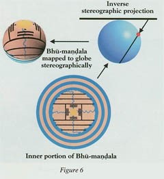
Bhu-mandala as a Polar Projection of the Earth Globe
We begin by discussing the interpretation of Bhu-mandala
as a planisphere, or a polar-projection map of the Earth globe. This is the
first model given by the Bhagavatam. A stereographic projection is an ancient
method of mapping points on the surface of a sphere to points on a plane. We
can use this method to map a modern Earth globe onto a plane, and the resulting
flat projection is called a planisphere (Figure 5). We can likewise view Bhu-mandala
as a stereographic projection of a globe (Figure 6). In India such globes
exist. In the example shown here (Figure 7, next page), the land area between
the equator and the mountain arc is Bharata-varsha, corresponding to
greater India. India is well represented, but apart from a few references to
neighboring places, this globe does not give a realistic map of the Earth. Its
purpose was astronomical, rather than geographical.


Although the Bhagavatam doesn’t explicitly
describe the Earth as a globe, it does so indirectly. For example, it points
out that night prevails diametrically opposite to a point where it is day.
Likewise, the sun sets at a point opposite where it rises. Therefore, the
Bhagavatam does not present the naive view that the Earth is flat.

We can compare Bhu-mandala with an
astronomical instrument called an astrolabe, popular in the middle Ages. On the
astrolabe, an off-centered circle represents the orbit of the sun—the ecliptic.
The Earth is represented in stereographic projection on a flat plate, called
the mater. The ecliptic circle and important stars are represented on another
plate, called the rete. Different planetary orbits could likewise be
represented by different plates, and these would be seen projected onto the
Earth plate when one looks down on the instrument.
The Bhagavatam similarly presents the orbits
of the sun, the moon, planets, and important stars on a series of planes
parallel to Bhu-mandala.
Seeing Bhu-mandala as a polar
projection is one example of how it doesn’t represent a flat Earth.


Bhu-mandala as a Map of the Solar System
Here’s another way to look at Bhu-mandala
that also shows that it’s not a flat-Earth model.
Descriptions of Bhu-mandala have
features that identify it as a model of the solar system. and Bhu-mandala as a planisphere map.. When
we do this, it looks at first like we’re back to the naive flat Earth, with the
bowl of the sky above and the underworld below.
In
India, the earth of the Puranas has often been taken as literally flat. But the
details given in the Bhagavatam show that its cosmology is much more
sophisticated.
Not only does the Bhagavatam use the ecliptic
model, but it turns out that the disk of Bhu-mandala corresponds in some
detail to the solar system (Figure 8). The solar system is nearly flat. The
sun, the moon, and the five traditionally known planets—Mercury through
Saturn—all orbit nearly in the ecliptic plane. Thus Bhu- mandala does refer to
something flat, but it’s not the Earth.


One striking feature of the Bhagavatam’s
descriptions has to do with size. If we compare Bhu-mandala with the
Earth, the solar system out to Saturn, and the Milky Way galaxy, Bhu-mandala
matches the solar system closely, while radically differing in size from Earth
and the galaxy.


Furthermore, the structures of Bhu-mandala
correspond with the planetary orbits of the solar system (Figure 9). If we
compare the rings of Bhu-mandala with the orbits of Mercury, Venus
(Figure 10), Mars, Jupiter, and Saturn, we find several close alignments that
give weight to the hypothesis that Bhu-mandala was deliberately designed as a
map of the solar system.


Until recent times, astronomers generally
underestimated the distance from the earth to the sun. In particular, Claudius
Ptolemy, the greatest astronomer of classical antiquity, seriously underestimated
the Earth-sun distance and the size of the solar system. It is remarkable,
therefore, that the dimensions of Bhu-mandala in the Bhagavatam are
consistent with modern data on the size of the sun’s orbit and the solar system
as a whole.
Jambudvipa as a
Topographical Map of South-Central Asia
Jambudvipa, the central hub of Bhumandala,
can be understood as a local topographical map of part of south- central Asia.
This is the third of the four interpretations of Bhu-mandala. In the
planisphere interpretation, Jambudvipa represents the northern hemisphere of
the Earth globe. But the detailed geographic features of Jambudvipa do not
match the geography of the northern hemisphere. They do, however, match part of
the Earth.
Six horizontal and two vertical mountain
chains divide Jambudvipa into nine regions, or varshas (Figure 11,top
left). The southernmost region is called Bharata-varsha. Careful study
shows that this map corresponds to India plus adjoining areas of south-central
Asia. The first step in making this identification is to observe that the
Bhagavatam assigns many rivers in India to Bharata- varsha. Thus
Bharata-varsha represents India. The same can be said of many mountains
in Bharata-varsha. In particular, the Bhagavatam places the Himalayas to
the north of Bharata-varsha in Jambudvipa.


A detailed study of Puranic accounts allows
the other mountain ranges of Jambudvipa to be identified with mountain ranges
in the region north of India. Although this region includes some of the most
desolate and mountainous country in the world, it was nonetheless important in
ancient times. For example, the famous Silk Road passes through this region.
The Pamir Mountains can be identified with Mount Meru and Ilavrita-varsha,
the square region in the center of Jambudvipa. (Note that Mount Meru does not
represent the polar axis in this interpretation.)
Other Puranas give more geographical details
that support this interpretation.
Bhu-mandala as a Map of the Celestial Realm of the Devas
We can also understand Bhu-mandala as
a map of the celestial realm of the demigods, or devas. One curious
feature of Jambudvipa is that the Bhagavatam describes all of the varshas
other than Bharata-varsha as heavenly realms, where the inhabitants live
for ten thousand years without suffering. This has led some scholars to suppose
that Indians used to imagine foreign lands as celestial paradises. But the Bhagavatam
does refer to barbaric peoples outside India, such as Huns, Greeks, Turks, and
Mongolians, who were hardly thought to live in paradise. One way around this is
to suppose that Bharata-varsha includes the entire Earth globe, while
the other eight varshas refer to celestial realms outside the Earth.
This is a common understanding in India.
But the simplest explanation for the heavenly
features of Jambudvipa is that Bhu-mandala was also intended to
represent the realm of the devas. Like the other interpretations we have
considered, this one is based on a group of mutually consistent points in the
cosmology of the Bhagavatam.
First of all, consider the very large sizes
of mountains and land areas in Jambudvipa. For example, India is said to be
72,000 miles (9,000 yojanas) from north to south, or nearly three times
the circumference of the Earth. Likewise, the Himalayas are said to be 80,000
miles high.
People in India in ancient times used to go
in pilgrimage on foot from one end of India to the other, so they knew how
large India is. Why does the Bhagavatam give such unrealistic distances? The
answer is that Jambudvipa doubles as a model of the heavenly realm, in which
everything is on a superhuman scale. The Bhagavatam portrays the demigods and
other divine beings that inhabit this realm to be correspondingly large. Lord Siva in comparison with Europe, according to one text of the
Bhagavatam.


Why would the Bhagavatam describe Jambudvipa
as both part of the earth and part of the celestial realm? Because there’s a
connection between the two. To understand, let’s consider the idea of parallel
worlds. By siddhis, or mystic perfections, one can take shortcuts across
space. This is illustrated by a story from the Bhagavatam in which the mystic
yogini Citralekha abducts Aniruddha from his bed in Dvaraka and transports him
mystically to a distant city.


Besides moving from one place to another in
ordinary space, the mystic siddhis enable one to travel in the all- pervading
ether or to enter another continuum. The classical example of a parallel
continuum is Krishna’s transcendental realm of Vrindavan, said to be
unlimitedly expansive and to exist in parallel to the finite, earthly Vrindavan
in India.
The Sanskrit literature abounds with stories
of parallel worlds. For example, the Mahabharata tells the story of how the
Naga princess Ulupi abducted Arjuna while he was bathing in the Ganges River . Ulupi pulled Arjuna down not to the riverbed, as we would expect,
but into the kingdom of the Nagas (celestial snakelike beings), which exists in
another dimension.


Mystical travel explains how the worlds of
the devas are connected with our world. In particular, it explains how
Jambudvipa, as a celestial realm of devas, is connected with Jambudvipa
as the Earth or part of the Earth. Thus the double model of Jambudvipa makes
sense in terms of the Puranic understanding of the siddhis.
Concluding
Observations:
The Vertical Dimension in Bhagavata Cosmology
The Vertical Dimension in Bhagavata Cosmology
For centuries the cosmology of the Bhagavatam
has seemed incomprehensible to most observers, encouraging many people either
to summarily reject it or to accept it literally with unquestioning faith. If
we take it literally, the cosmology of the Bhagavatam not only differs from
modern astronomy, but, more important, it also suffers from internal
contradictions and violations of common sense. These very contradictions,
however, point the way to a different understanding of Bhagavata cosmology in
which it emerges as a deep and scientifically sophisticated system of thought.
The contradictions show that they are caused by overlapping self-consistent
interpretations that use the same textual elements to expound different ideas.
In the Bhagavatam, the context-sensitive
approach was rendered particularly appropriate by the conviction that reality,
in the ultimate issue, is avak-manasam, or beyond the reach of the
mundane mind or words. This implies that a literal, one-to-one model of reality
is unattainable, and so one may as well pack as much meaning as possible into a
necessarily incomplete description of the universe. The cosmology of the
Bhagavata Purana is a sophisticated system of thought, with multiple layers of
meaning, both physical and metaphysical. It combines practical understanding of
astronomy with spiritual conceptions to produce a meaningful picture of the
universe and reality.
Hari om Tat Sat
o